


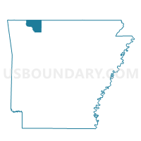
Piney Voting District, Carroll County, Arkansas
About
Outline

Summary
| Unique Area Identifier | 526060 |
| Name | Piney Voting District |
| County | Carroll County |
| State | Arkansas |
| Area (square miles) | 17.97 |
| Land Area (square miles) | 17.97 |
| Water Area (square miles) | 0.00 |
| % of Land Area | 100.00 |
| % of Water Area | 0.00 |
| Latitude of the Internal Point | 36.21114000 |
| Longtitude of the Internal Point | -93.48247600 |
Maps


Graphs
Select a template below for downloading or customizing gragh for Piney Voting District, Carroll County, Arkansas


Neighbors
Neighoring Voting District (by Name) Neighboring Voting District on the Map
- Cabanal Voting District, Carroll County, AR
- Dryfork Voting District, Carroll County, AR
- Liberty Voting District, Carroll County, AR
- Omega Voting District, Carroll County, AR
- Osage Voting District, Carroll County, AR
Top 10 Neighboring County Subdivision (by Population) Neighboring County Subdivision on the Map
- Omega township, Carroll County, AR (489)
- Osage township, Carroll County, AR (418)
- Cabanal township, Carroll County, AR (381)
- Dry Fork township, Carroll County, AR (292)
- Piney township, Carroll County, AR (226)
- Liberty township, Carroll County, AR (158)
Top 10 Neighboring Unified School District (by Population) Neighboring Unified School District on the Map
- Berryville Public Schools, AR (10,893)
- Green Forest School District, AR (7,384)
- Alpena School District, AR (2,960)